Log in
All resources
Create a design
4,838 Free Artworks of Maps Of France
bibliothèque nationale de france
maps of spain by tomas lopez
maps of paris from bibliothèque nationale de france
environs de paris levés géométriquement by jean delagrive (1731-1742)
old maps of castile and león
maps from gallica
maps by alexis-hubert jaillot
orientalist painting
maps from géographie illustrée de la france et de ses colonies
18th-century maps of andalusia
maps of cagliari by braun & hogenberg
maps of valletta by braun & hogenberg
18th-century maps of the bahamas
18th-century maps of hispaniola
maps from gallica
old maps of psarà
18th-century maps of veneto
1700s maps of slovenia
nouvelle géographie universelle, vol. ii
schematic maps of france
maps of helsingborg by braun & hogenberg
maps of lund by braun & hogenberg
old maps of henan
maps with figures
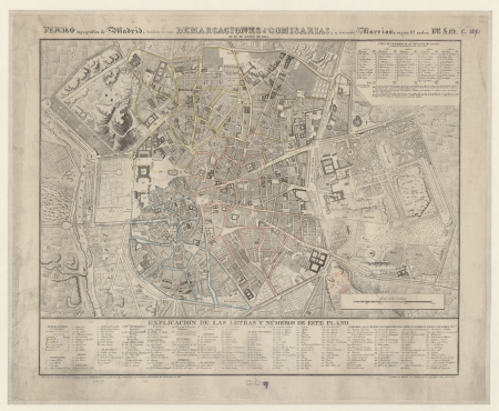
madrid in the 1820s
maps by juan lopez
le royaume de france distingué by guillaume sanson
1724 maps of france
maps by willem and johannes blaeu
17th-century maps of france
environs de paris levés géométriquement by jean delagrive (1731-1742)
maps of paris from bibliothèque nationale de france
environs de paris levés géométriquement by jean delagrive (1731-1742)
maps of paris from bibliothèque nationale de france
environs de paris levés géométriquement by jean delagrive (1731-1742)
maps of paris from bibliothèque nationale de france
environs de paris levés géométriquement by jean delagrive (1731-1742)
maps of paris from bibliothèque nationale de france
environs de paris levés géométriquement by jean delagrive (1731-1742)
maps of paris from bibliothèque nationale de france
maps from géographie illustrée de la france et de ses colonies
orientalist painting
le royaume de france distingué by guillaume sanson
1724 maps of france
le royaume de france distingué by guillaume sanson
1724 maps of france
19th-century maps of ille-et-vilaine
1847 maps of france
maps from géographie illustrée de la france et de ses colonies
orientalist painting
maps from géographie illustrée de la france et de ses colonies
orientalist painting
environs de paris levés géométriquement by jean delagrive (1731-1742)
maps of paris from bibliothèque nationale de france
environs de paris levés géométriquement by jean delagrive (1731-1742)
maps of paris from bibliothèque nationale de france
environs de paris levés géométriquement by jean delagrive (1731-1742)
maps of paris from bibliothèque nationale de france
environs de paris levés géométriquement by jean delagrive (1731-1742)
maps of paris from bibliothèque nationale de france
beschreibung der städt der welt - braun & hogenberg - btv1b52512111k
dresden in the 1580s
1702 maps of france
1702 in guyenne
maps of the kingdom of seville
maps of spain by tomas lopez
maps of the kingdom of córdoba (crown of castile)
maps of spain by tomas lopez
old maps of auvergne
1660s maps of france
maps of bordeaux by braun & hogenberg
maps of nîmes by braun & hogenberg
map of the upper rhenian circle by sanson
maps by nicolas sanson
maps of the kingdom of seville
maps of spain by tomas lopez
maps of ancient italy by philipp clüver
old maps of the alps
maps of the kingdom of seville
maps of spain by tomas lopez
maps of the kingdom of seville
maps of spain by tomas lopez
1574 maps of africa
1570s maps of egypt
dheulland map of paris
maps by a. taride
barcelona in the 1800s
maps by juan lopez
map of italy by guillaume delisle (1700)
1700s maps of italy
1770s maps of the americas
maps by tomas lopez
theatre geographique du royaume de france (1632)
maps of provence by pierre-jean de bompar
maps of cagliari by braun & hogenberg
maps of valletta by braun & hogenberg
ptolemy's 3rd european map
maps by girolamo porro
georges barthélemy médéric flamand
chotts
atlas minor gerardi mercatoris (1621, maps)
17th-century maps of siberia
carte generale du tres-haut, tres-puissant et tres chrestien royaume de france
maps by nicolas sanson
1770s maps of the americas
maps by tomas lopez
17th-century maps of poitou
1660s maps of france
arnold van langren map of southwest africa
1600 maps of africa
maps of raja ampat regency
dutch-language maps
tresor des cartes geographiques (1659)
1650s maps of france
maps in the library of congress
battle of cherbourg (1864)
maps from géographie illustrée de la france et de ses colonies
orientalist painting
maps from géographie illustrée de la france et de ses colonies
orientalist painting
maps of the iberian peninsula by guillaume delisle
1700s maps of the iberian peninsula
guide joanne espagne et portugal-1915
1915 maps
old maps of guizhou
maps from gallica
maps by pieter van der keere
maps by abraham ortelius
maps by pieter van der keere
old maps of zutphen
maps by pieter van der keere
old maps of flanders
1780s maps of the balkans
maps by tomas lopez
20th-century maps of oise
maps from gallica
reconstructions of old maps
german renaissance
illustration
maps
reconstructions of old maps
german renaissance
maps by willem and johannes blaeu
old maps of gironde
17th-century maps of france
old maps of loiret
maps by alexis-hubert jaillot
maps by nicolas sanson
atlas geographico del reyno de españa e islas adjacentes (1757)
1757 maps of spain
1570s maps of africa
1570s maps of egypt
maps of paris from bibliothèque nationale de france
plan de roussel
historisk atlas (stockholm, norstedt & söner, 1880)
old maps of the carolingian empire
18th-century maps of north africa
maps by tomas lopez
maps by pieter mortier
maps from gallica
maps of the land of valkenburg
guillaume sanson
bibliothèque nationale de france
dheulland map of paris
maps of the land of valkenburg
guillaume sanson
maps of spain by tomas lopez
1779 maps of spain
maps of spain by tomas lopez
1773 maps of spain
maps of spain by tomas lopez
1773 maps of spain
maps of spain by tomas lopez
1779 maps of spain
maps of vangiones by sanson
1670s maps of hesse
maps of spain by tomas lopez
old maps of gran canaria
atlas minor gerardi mercatoris (1614, maps)
17th-century double hemisphere world maps
maps of spain by tomas lopez
1782 maps of spain
old maps of tenerife
1779 maps of spain
maps of spain by tomas lopez
1779 maps of spain
maps of spain by tomas lopez
1782 maps of spain
maps of spain by tomas lopez
1779 maps of spain
maps of the course of the rhine by guillaume sanson
guillaume sanson
gaspard de chabrol
maps from gallica
map of the circle of austria by sanson
1700s maps of austria
17th-century maps of the british isles
maps by abraham ortelius
maps by juan lopez
1835 maps of spain
maps by alexis-hubert jaillot
maps by guillaume sanson
18th-century maps of the philippines
baroque painting
sanson maps of the netherlands
maps by alexis-hubert jaillot
17th-century maps of cambridgeshire
old county maps of cambridgeshire
maps by tomas lopez
1791 maps of europe
901 - 1000 of 4,838
Next page
/ 49

![Calaris; Malta; Rhodes; Famagusta / [Georg Braun]; [Franz Hogenberg]](https://cdn.creazilla.com/illustrations/10000490984/calaris-malta-rhodes-famagusta-georg-braun-franz-hogenberg-md.jpg)

![From Sio and Psara / [by Allain Manesson-Mallet], 1683](https://cdn.creazilla.com/illustrations/10001127472/from-sio-and-psara-by-allain-manesson-mallet-1683-sm.webp)


![Treasure of geographical maps of the main states of the universe [...], 1659](https://cdn.creazilla.com/illustrations/10001054877/treasure-of-geographical-maps-of-the-main-states-of-the-universe-1659-sm.jpg)


![Queicheu imperii sinarum provincia decimaquarta / [tirée du P. Martini]; Exc. I. Blaeu, 1655](https://cdn.creazilla.com/illustrations/10001381799/queicheu-imperii-sinarum-provincia-decimaquarta-tire-du-p-martini-exc-i-blaeu-1655-md.jpg)


![[Reproduction of the terrestrial globe (orbis imago) by Jean Stabius, 1515] (Facsimile reproduction)](https://cdn.creazilla.com/illustrations/10000781714/reproduction-of-the-terrestrial-globe-orbis-imago-by-jean-stabius-1515-facsimile-reproduction-sm.webp)
![BOUCHER, Lucien. Air France [zodiac map], 1953.](https://cdn.creazilla.com/illustrations/3148546/boucher-lucien-air-france-zodiac-map-1953-illustration-md.jpeg)
![[Reproduction of the terrestrial globe (orbis imago) by Jean Stabius, 1515] (Facsimile reproduction)](https://cdn.creazilla.com/illustrations/10000450806/reproduction-of-the-terrestrial-globe-orbis-imago-by-jean-stabius-1515-facsimile-reproduction-sm.jpg)